Geospatial consulting
For organizations and consulting teams: spatial analysis, data preparation and quality control. Possible deliverables include structured GIS datasets, metadata, analytical maps and a methodology note.
I help organizations, researchers and publishers analyze the places they work in. I turn geographic data into reliable information, useful analysis and clear maps designed to support decisions and publications.
Santa Cruz de la Sierra, Bolivia
Remote or hybrid collaboration

I am Lionel Guemdjo. I combine GIS analysis, data rigor and cartographic design to make territories easier to understand.
Each engagement is scoped around your question, available data, output formats and timeline. The services below can be combined.
For organizations and consulting teams: spatial analysis, data preparation and quality control. Possible deliverables include structured GIS datasets, metadata, analytical maps and a methodology note.
For publishers and research teams: map design for books, atlases and scientific publications. Possible deliverables include map layouts, legends, print files and digital versions. Historical projects are scoped according to available sources.
For teams working on agriculture, land and urban development: territorial data structuring and GIS analysis tailored to the study area. Possible deliverables include mapped assessments, GIS layers and spatial summaries.
Climate research, healthcare, conservation and territorial cartography: explore the methods and completed documents.
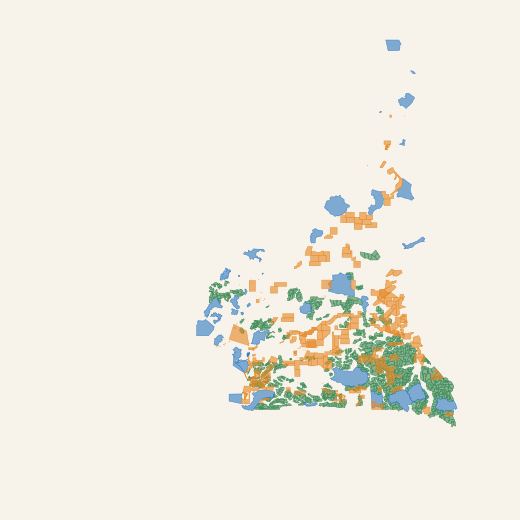
Explore mining permits, forest concessions and wildlife protected areas across Cameroon in one interactive atlas.
An independent portfolio project showing how open-source geospatial technologies turn spatial datasets into an accessible web mapping application.
QGIS for data preparation; GeoServer WMS/WFS in the publishing workflow. The supplied web version uses GeoJSON directly with OpenLayers, HTML, CSS and JavaScript; hosting on Cloudflare.
Video demonstration · 3 min 37 s
Data: Cameroon Interactive Forest Atlas — Ministry of Forestry and Wildlife (MINFOF) / World Resources Institute (WRI). MINFOF / WRI ↗ · CC BY 4.0
Independent portfolio project. Counts refer to the supplied datasets; this is not an official or exhaustive inventory.
A GIS framework identifying agroclimatic zones and areas exposed to drought, excessive wetness and heat stress.
Climate, satellite and reanalysis data combined over the 1991–2020 reference period. Harmonization, inter-product comparison and agroclimatic zoning support climate-risk assessment and agricultural planning.
Co-authored with Gleb I. Zagrebin · Izvestia Vuzov. Geodesy and Aerophotosurveying · 70(1), 2026.
CHIRPS · ERA5-Land · WorldClim 2 · Köppen-Geiger
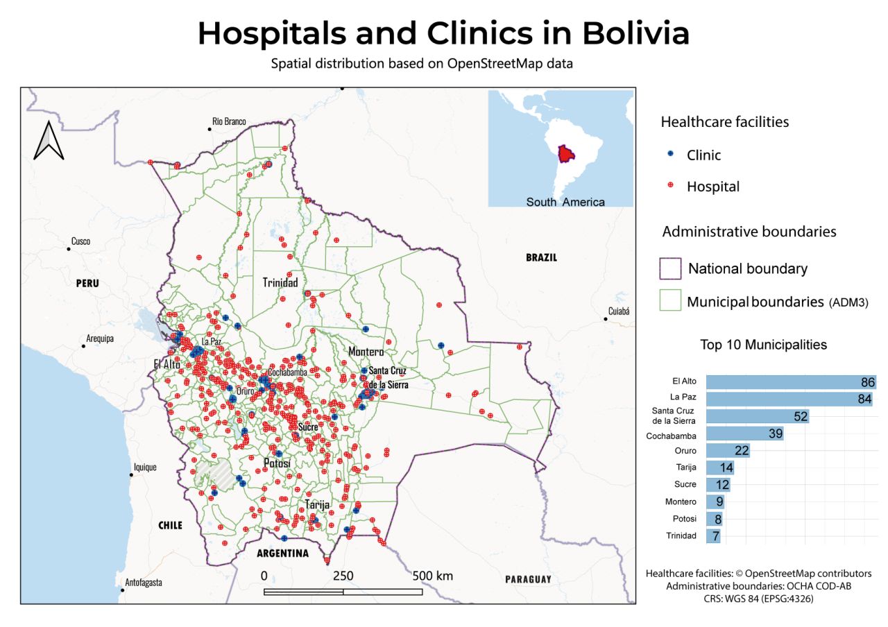
A national overview of healthcare facilities mapped in OpenStreetMap, aggregated by municipality.
Data extraction and validation, reclassification of Centros de Salud and Puestos de Salud, spatial joins to administrative boundaries, municipal aggregation and visualization with QGIS and DataPlotly.
Mapped facilities: El Alto 86 · La Paz 84 · Santa Cruz de la Sierra 52 · Cochabamba 39 · Oruro 22. This is not an official or exhaustive inventory: results depend on OpenStreetMap coverage and tagging quality.
QGIS · DataPlotly · © OpenStreetMap contributors · OCHA COD-AB
Mapped facilities: El Alto 86 · La Paz 84 · Santa Cruz de la Sierra 52 · Cochabamba 39 · Oruro 22. This is not an official or exhaustive inventory: results depend on OpenStreetMap coverage and tagging quality.
A thematic map combining terrain, hydrography and major settlements in Sara Province, Bolivia.
Designed in QGIS to balance geographic information, visual hierarchy and legibility: terrain, waterways, settlements, legend and locator map.
A cartographic document designed to offer a clear, concise view of the territory.
QGIS · Natural Earth · HydroSHEDS · SRTM 30 m / CGIAR-CSI
Using Cameroon as a case study, a proposed geospatial database model to organize, classify and update information on African protected areas.
The work presents a map of protected areas in Cameroon, data structured in Excel and an example of visualization in QGIS. The proposed schema defines ten fields: ID, code, name, category, country, region, area, creation and establishment dates, and management organization.
Unpublished research manuscript. It proposes an Africa-wide extension, rather than documenting a deployed continental platform. The map reflects the original study data and is not guaranteed to be current.
QGIS · Excel · Data modeling · Protected areas
Define objectives, the study area and deliverables.
Structure the data and check its consistency.
Interpret spatial relationships and patterns.
Present understandable, documented results.
I am Lionel Guemdjo, a GIS specialist and geospatial analyst based in Bolivia. My background combines geoinformatics, cartography and practical experience in multicultural settings.
I work on agriculture, natural resources and planning challenges. My goal is to make territorial information reliable, understandable and useful for decision-making.
Esri: Cartography, GeoBIM, Data Visualization. Graphic Design Specialization — California Institute of the Arts.
Cadastral Engineer at Mosgorgeotrest (2021–2022): plan updates, digitization and data structuring. Civil engineering internship at Pecsis (2016): AutoCAD drawings and Revit modeling.
GIS Analyst Consultant · Since November 2023 · Remote
Internship · GIS Specialist and Cartographer · Moscow
Analysis of wetlands, soils and rivers around drilling areas. Use of satellite imagery, SRTM data, SWIR bands and WMS layers with ArcGIS and Google Earth.
Internship · GIS Analyst · Moscow
Spatial data collection and analysis, mapping points of interest and creating maps with QGIS and MapInfo Pro, followed by layouts in Illustrator and InDesign.
Before starting, we agree on what needs to be produced. Scope, schedule and quotation follow this initial discussion.
A decision to inform, a map to publish or a territory to analyze.
Datasets, documentary sources, study area and usage constraints.
Expected formats, audience, level of detail and target delivery date.
Tell me which service you need, your study area, available data, expected formats and deadline. These details will help scope a tailored proposal.
Santa Cruz de la Sierra, Bolivia
Remote or hybrid collaboration
Projects in Africa, Latin America and internationally